
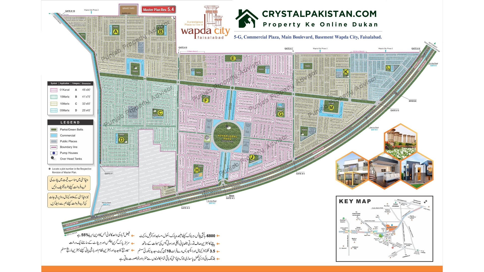
Wapda City Faisalabad is one of the most well-planned and organized housing societies in the city. Spread across 650 acres, it was originally designed for employees of the Water and Power Development Authority (WAPDA), but it has grown to attract a wide range of buyers and investors. Understanding the map of Wapda City is crucial for anyone looking to buy a property or plan their investment. Here, we’ll break down the key aspects of the Wapda City Map, the layout, and its accessibility, making it easy for you to navigate.
Table of Contents
Wapda City Location
Wapda City is situated on the main Faisalabad Canal Expressway, providing quick access to major parts of the city and connecting to the M-3 Motorway. The expressway connects the society to Faisalabad’s industrial hubs, business centers, and important landmarks like Abdullahpur Chowk and Gattwala Commercial Hub.
Navigating Wapda City Faisalabad
Wapda City’s layout includes several blocks, each with its own set of residential and commercial plots. The society is divided into blocks A through M, offering various residential plot sizes, such as 5 Marla, 10 Marla, 15 Marla, and 1 Kanal. These blocks are connected by wide roads and feature ample green spaces for a comfortable living environment.
The map also includes commercial areas strategically placed across different blocks, making it convenient for residents to access shops and businesses.
Key Information about Wapda City Faisalabad
| Features | Details |
| Total Area | 650 Acres |
| Main Road | Faisalabad Canal Expressway |
| Nearby Landmarks | Abdullahpur Chowk, Gattwala Commercial Hub, M-3 Industrial City |
| Blocks | A to H, J to M |
| Residential Plot Sizes | 5 Marla, 10 Marla, 15 Marla, 1 Kanal |
| Commercial Areas | Within blocks for easy access |
| Developer | WAPDA Employees Cooperative Housing Society |
| NOC Status | FDA-Approved |
Accessibility of Wapda City
Wapda City is easily accessible from major points within Faisalabad and neighboring areas. Key access routes include:
- Faisalabad Canal Expressway
- Abdullahpur Chowk
- Motorway Toll Plaza
- Gattwala Commercial Hub
- Faisalabad Sangla Hill Road
These routes make it convenient for residents and investors to travel to and from the society without hassle.
Block Layout
Each block in Wapda City is thoughtfully designed with wide roads, parks, and easy access to commercial areas. Block A to H and J to M offer residential plots, while commercial areas are located at key points in each block. The central park, spanning 12 acres, is a standout feature, offering green spaces for residents to enjoy.
Benefits of the Map Layout
Wapda City’s map layout has been designed with both convenience and lifestyle in mind. Here’s why:
- Clear Division of Blocks: Each block has an equal market value, ensuring no drastic price differences between plots.
- Wide Main Boulevards: The wide roads and boulevards reduce traffic congestion, ensuring smooth travel within the society.
- Green Spaces: Nearly 47% of the area is reserved for parks and open spaces, enhancing the quality of life for residents.
How to Use the Map for Investment
Investors can use the Wapda City map to identify high-demand areas, such as plots near the commercial hubs or main boulevards. Residential plots in these areas tend to have a higher market value due to easy accessibility and proximity to amenities.
Understanding the map of Wapda City Faisalabad is essential for anyone considering buying a plot or home here. With its strategic location, well-planned layout, and easy access to key parts of the city, Wapda City is a prime choice for both residents and investors. Whether you’re looking for a peaceful residential community or a smart investment opportunity, Wapda City offers everything you need.


Join The Discussion